
सञ्चिका:Badami-chalukya-empire-map.svg

मूलसञ्चिका (SVG सञ्चिका, साधारणं १,५१० × १,७५३ चित्राणवः (pixels), सञ्चिकायाः आकारः : ३३९ KB)
सारांशः
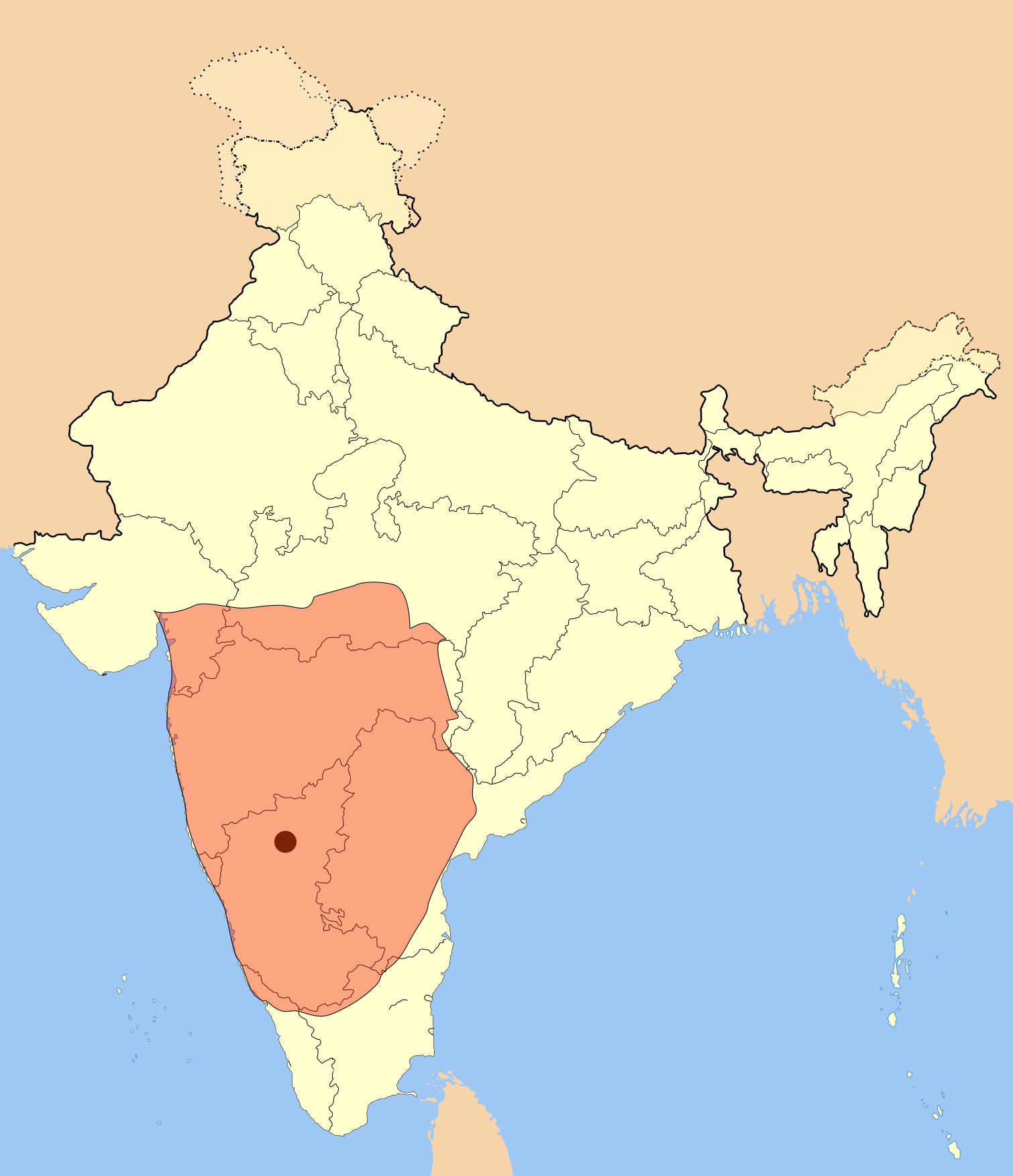
I used Image:India-locator-map-blank.svg as base and edited myself using inkspace and created it by looking at the following source.
Suryanath U. Kamat, A Concise history of Karnataka from pre-historic times to the present, Jupiter books, MCC, Bangalore, 2001 (Reprinted 2002) OCLC: 7796041 p327
A province of this empire comprising of Andhra region became the "Eastern Chalukyas" in the years following the death of Pulakesi II.
Note: Original source has overlay of Kadamba, Rastrakuta and Western Ganga kingdom maps on the same page, I placed only the Badami Chalukya empire map.
| वर्णनम् | Badami Chalukya Empire Map |
| दिनाङ्क | |
| स्रोतः | स्वकार्यम् |
| लेखकः | Mlpkr |
अनुमतिदानम्

|
अस्य प्रलेखस्य प्रतिकृतीकरणं, पुनर्वितरणं, परिवर्तनं वा / च कर्तुम् अधोनिर्दिष्टनियमानुसारम् अनुमतिः दत्ता GNU Free Documentation License, Version 1.2 or any later version published by the Free Software Foundation; with no Invariant Sections, no Front-Cover Texts, and no Back-Cover Texts. A copy of the license is included in the section entitled GNU Free Documentation License |
| एषा सञ्चिका क्रिएटिव कॉमन्स-Attribution-Share Alike 3.0 Unported अनुमतिपत्रान्तर्गततया अस्ति । | ||
| ||
| इयम् अनुमतिशृङ्खला GFDL भागत्वेन अस्यां सञ्चिकायां योजितम् अनुमतेः अद्यतनीकरणम् । |
- त्वं स्वतन्त्रः/स्वतन्त्रा :
- वितरितकरणार्थम् – प्रतिलिपिकरणार्थं, वितरितकरणार्थं, सञ्चारितकरणार्थं च
- सुशोभयितुम् (to remix) – कार्यम् अनुकूलं करणार्थम्
- निम्नलिखितावस्थानाम् अन्तर्गततया :
- समारोपः (attribution) – भवता/भवत्या रचनायाः श्रेयः उपयोगसंस्थितकत्रा अथवा लेखकेन दर्शितमाध्यमेन दातव्यः भविष्यति । (परन्तु सः भवते/भवत्यै अथवा भवता/भवत्या रचनायाः प्रयोगस्य समर्थनं करोति इति तस्य विचारः न भवेत्)।
- समानतया वितर्यताम् – यदि भवान्/भवती एतस्मिन् कार्ये किमपि परिवर्तनं, अस्य आधारेण नवीनरचनां वा करोति, तर्हि नवरचितरचनायाः वितरणम् एतस्याः उत एतादृश्याः उपयोगसंस्थित्याः अन्तर्गततया कर्तुं शक्नोति ।
सञ्चिकायाः इतिहासः
सञ्चिका तत्समये कीदृशी आसीदिति द्रष्टुं दिनाङ्कः/समयः नुद्यताम् ।
| दिनाङ्कः/समयः | लघ्वाकृतिः | आयामाः | सदस्यः | टिप्पणी | |
|---|---|---|---|---|---|
| वर्तमानः | ००:२८, १९ जुलै २०१७ | | १,५१० × १,७५३ (३३९ KB) | Renato de Carvalho Ferreira | Ajustes gerais |
| २२:४९, २७ मे २००७ |  | १,६५१ × १,७५३ (४३२ KB) | Mlpkr | I used Image:India-locator-map-blank.svg as base and edited myself using inkspace and created it by looking at the following source. Suryanath U. Kamat, A Concise history of Karnataka from pre-historic times to the present, Jupiter books, MCC, Bangalore | |
| २३:०९, २६ मे २००७ |  | १,६५१ × १,७५३ (४३२ KB) | Mlpkr | == Summary == I used Image:India-locator-map-blank.svg as base and edited myself using inkspace and created it by looking at the following source. Suryanath U. Kamat, A Concise history of Karnataka from pre-historic times to the present, Jupiter books, | |
| २२:२५, २६ मे २००७ |  | १,६५१ × १,७५३ (४३१ KB) | Mlpkr | {{Information |Description= |Source=self-made |Date= |Author= User:Mlpkr }} |
सञ्चिकायाः उपयोगः
अनया सञ्चिकया सह न किमपि पृष्ठं सल्लग्नम् अस्ति
वैश्विकसञ्चिकायाः उपयोगः
एतां सञ्चिकाम् अधोनिर्दिष्टाः वीक्यः उपयुञ्जते:
- ar.wikipedia.org इत्यस्मिन् उपयोगः
- ba.wikipedia.org इत्यस्मिन् उपयोगः
- bn.wikipedia.org इत्यस्मिन् उपयोगः
- ca.wikipedia.org इत्यस्मिन् उपयोगः
- da.wikipedia.org इत्यस्मिन् उपयोगः
- en.wikipedia.org इत्यस्मिन् उपयोगः
- es.wikipedia.org इत्यस्मिन् उपयोगः
- fi.wikipedia.org इत्यस्मिन् उपयोगः
- fr.wikipedia.org इत्यस्मिन् उपयोगः
- gu.wikipedia.org इत्यस्मिन् उपयोगः
- hi.wikipedia.org इत्यस्मिन् उपयोगः
- hu.wikipedia.org इत्यस्मिन् उपयोगः
- hy.wikipedia.org इत्यस्मिन् उपयोगः
- id.wikipedia.org इत्यस्मिन् उपयोगः
- it.wikipedia.org इत्यस्मिन् उपयोगः
- ja.wikipedia.org इत्यस्मिन् उपयोगः
- ka.wikipedia.org इत्यस्मिन् उपयोगः
- kn.wikipedia.org इत्यस्मिन् उपयोगः
- ko.wikipedia.org इत्यस्मिन् उपयोगः
- lt.wikipedia.org इत्यस्मिन् उपयोगः
- ml.wikipedia.org इत्यस्मिन् उपयोगः
- mr.wikipedia.org इत्यस्मिन् उपयोगः
- ms.wikipedia.org इत्यस्मिन् उपयोगः
- ne.wikipedia.org इत्यस्मिन् उपयोगः
अस्याः सञ्चिकायाः वैश्विकोपयोगस्य अधिकविवरणम् दृश्यताम् ।